Tuesday, November 22, 2011

Death Valley II: The Valleying

Believe it or not, the photos I posted in the last update were heavily weeded for space. There were still too many to fit in any stories, not to mention any pictures I took in the Mojave Preserve. So we have a sequel.

No surprise, but there isn't any water in Death Valley. Hauling enough water for drinking, cleaning, and cooking on an overnight hike, especially in an arid environment, is simply too bulky and heavy to manage, so again I was staying in campgrounds and doing day-hikes. Just as well, because Death Valley is unimaginably vast; it often took hours to get to a trailhead, leaving less time to hike, especially with scant winter daylight. But this gave me lots of time to drive around the unimaginable vastness listening to compelling albums. Including but not limited to:

Desert by Katherine Follett on Grooveshark
A lot of the trailheads were also at the end of dirt roads, variously described as "Improved," "High Clearance," or "Four-Wheel Drive." There wasn't a road that Nonno had any trouble with, though I didn't try to take it over anything seriously rough or soft; Subaru can talk about all-wheel-drive all they want, but the car remains a glorified station wagon.

Aside: Did you know that "Subaru" is the Japanese name for the Pleiades? Hence the logo.

When I pulled into my second night's campground, I spotted Nonno's identical twin at a nearby site. It belonged to two older guys who'd been traveling for a few weeks. We ended up running into each other several times over my visit, each time complementing each other on our fine automobiles. They reassured me that the Sube could handle pretty much any of the roads I wanted to take it on.

Another resident of the same campground was Laurie, a woman I'd estimate to be in her late 60s, early 70s, traveling with no one but her hyper miniature schnauzer, Angel. She'd bested me, starting in May and visiting something like thirty national parks. Ahh, retirement.

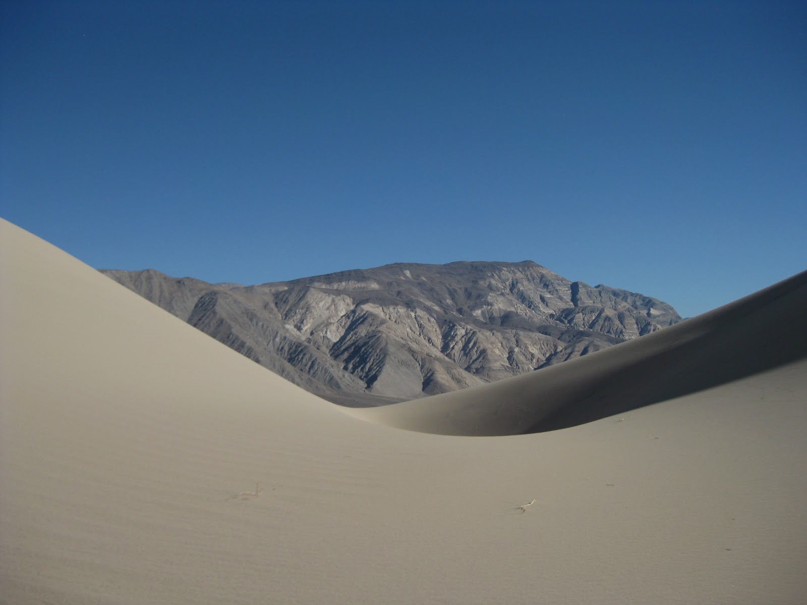
For a place named Death Valley, it was awfully pleasant. Daytime highs averaged between 70 and 75, and nights got down to maybe the 40s. A breeze would often pick up at night, but usually not until after I was snug in my tent, if I wasn't stargazing. Winter is also the park's "in" season, so unlike parks in the Sierras, everything was open and functioning, including showers and laundry. I probably could have spent another several days there, seeing things I missed, but after eight days alternating between dunes, canyons, and salt flats, I was ready to move on.

After leaving Death Valley, I spent a couple of days in the guidebook's highly recommended Mojave National Reserve, not too far south. It was a two-day whirlwind tour, but I'm glad I did it. The Mojave Reserve boasts the world's biggest Joshua tree forest, some cool volcanic features, and MOAR SAND DUNES.

The Joshua trees here were plentiful and happy.

A young one. Joshua trees are a kind of yucca, which mostly grows as a shrub-like succulent.
The big, old ones get feet.


My first night's campsite was in the Joshua tree forest, studded with weirdly eroded granite outcroppings. I was fond of this cactus growing amid the biscotti-shaped rocks.


The next day, I did a hike in "Hole in the Wall" canyon. It was one of several volcanic features around the reserve. These weird cliffs were formed by gas bubbles trapped in easily eroded volcanic ash and pumice.


Another volcanic feature in the park was a "lava tube." When very fluid lava flows through an existing channel, such as a riverbed, the melted rock often cools and solidifies on the top and sides, forming a solid tube with liquid lava flowing down the center. When the eruption stops, the liquid lava flows out, leaving a long, drinking-straw shaped cave. You could enter this one by a ladder placed in a cave-in in the ceiling.

The entry
Lava is black.
The low light meant a long shutter time, which meant blurry.
The second night, I camped in the southern part of the park, right on another set of beautiful sand dunes. These were "singing" or "booming" dunes, which make a grumbling noise when you walk on the loose sand. (Supposedly, the Eureka dunes in Death Valley also boomed, but only under very dry conditions, and it had rained the night before.) Descriptions of "booming" dunes always sounded so strange and supernatural, but in person, it doesn't act much different than squeaky snow.

I had just enough time to sweat my way up the tallest dune as the sun set.


By this time, I was trying to finish all my perishable food before heading to Tucson and civilization, and I'd run out of coffee. The only place to get caffeinated within a hundred miles was the cafe at the reserve's visitor center, in a converted train depot in the middle of nothing. I had a couple of nice mornings there, chatting with other travelers (one of whom wore an "I LOVERMONT" T-shirt) and the owner. The second morning, there was a centennial steam train stopping at the depot. The place was overrun with train enthusiasts. But even I had to admit that it was an impressive beast up close.


The wheels were about five feet tall.
After the train pulled away, I said goodbye and started the very long drive to Tucson, Arizona, where I landed at my friends' Timm and Lynn's house. I'll be here through turkey day, glad to be among friends.

Have a wonderful Thanksgiving--I'm thinking of you all!

Monday, November 21, 2011

Death Valley/Mojave National Preserve

Yosemite left me cold, but only literally. I couldn't wait to get over the mountains to the desert. Unfortunately, many of the nearby mountain roads were closed for the season, so I had a long drive north to find an open pass, which spit me out in western Nevada. It did provide a beautiful opportunity to listen to "No Flashlight" under a full moon while I crossed the range. I spent the night roadside camping in a truly empty national forest, sleeping in the car to keep out the cold.


The next morning, I stopped by Mono Lake, a weird alkaline lake with mineral rock formations rising from the depths. It still wasn't low elevation enough to be warm, so I didn't stay long.

This guard rail collects bumper stickers. Mono Lake in the background.

Tufa.
Tufa formations that used to be in the water before civil projects drained it by several feet.

And finally--Death Valley! And it was raining and in the 50s. No matter--the weather warmed and cleared while I was there, and I took a truly staggering number of photos; so many that I'll try to keep the word stuff to a minimum. I've heard a few of you guys don't read the words anyway *cough*Sarah*cough*.

I always imagined Death Valley to be a giant expanse of nothing. Don't get me wrong, there was a whole lot of nothing there. And don't get me double wrong--there's something appealing about giant expanses of nothing. But there was so much else--sand dunes, rock formations, slot canyons. It was easy to go crazy with the photos in the clear desert air.
Dawn over the desert. It rained off and on that first day.
You're a captive audience--only a couple gas stations over many hundreds of miles. Jerks.

First set: Eureka dunes, reached by a tooth-jarring dirt road.


The foot path winds across each of the crests on its way to the tallest dune.

After descending the steep side of a dune.
Free color blindness test with canyon hike!!
Fall Canyon


Weird Seussian plants

An eroding volcanic crater. You could hike to the bottom.


Spot the people about 3/4 of the way up the trail from the rim to the bottom

Pale desert holly, complete with berries.

Sun setting over strangely eroded mountains outside the crater

A smaller side crater.

Second set from the Panamint Dunes, which were about a 2-hour hike across desert scrub. These dunes were deserted and pristine.

I took a lot of photos of dunes.


A common dune resident


Many desert National Parks have a habit of taking the trash people leave in the desert and calling it "Historial Sites."
This guy showed up just after dark as I was making dinner. He's cute, but he left a turd on my picnic table.


The edges of the salt flats, the lowest point in the western hemisphere.

Note the people on the edges of the salt. You can also spot the parking area along the bottom of the mountains.

Sunrise on the salt flats.

BRING ME THE WORLD'S LARGEST MARGARITA GLASS!!!!


Telescope peak, at 11,000 ft.

The borders make these cool toothy-fish cracks.

The wetter spots have a fleecy texture.

Artists' drive, where you can view mineral-rich rocks with unbelievable colors.


Mosaic Canyon
So named.
Cave at the entrance to Willow Canyon. It looked like there were frequently used trails going to the entrance. But there were also a lot of huge bones scattered around. I don't think people are the ones making the trails. I didn't stay there long.

At the entrance to a slot canyon off Sidewinder Canyon


SURPRISE BIG SPIDER! According to the park guide, only male tarantulas are usually spotted walking about, and only during autumn mating season. I saw several. They are fuzzy.
Phew--you made it! I still have more photos to post from the past few adventures, these from the Mojave reserve. I'll wait for a later update.