I just returned from six days in Zion. I spent the first four in the back country, and the last one and a half in the main Zion Canyon. I got lotsa pictures, so I'll try to organize chronologically.
The day I arrived, I stayed in Springdale, the resort town just outside the park, where I indulged in prawn tacos and a fancy hotel. Then, I loaded up my new 2-liter water bottle (which weighs
four and a half pounds when full), about twice as much food and clothing as I needed, and met my shuttle to the trailhead early the next morning.
Day 1
The first day of hiking had some interesting moments, but overall wasn't that spectacular. It was up in the high country, away from the main rock formations of Zion Canyon, and was mostly a pleasant, if relatively boring, walk through the trees. There were a few spots where strange formations rose out of the forest.
 |
| "Job's Head." All the formations have religious names. Some sources say each one was named by Mormons, but others say that after "Zion" got its name from them, everyone else just went with the theme. |
There was also a spur trail to an overlook, which gave the first glimpse of the truly weird formations of the Zion Canyon.
 |
| "Guardian Angel," one of many cone-shaped formations |
 |
| There was no one around for me to point out that this one looks just like Jabba the Hut. |
I camped on the edge between a pleasant meadow and a steep, but otherwise unremarkable, canyon.
Day 2
The next day continued along the ridges, but with a much more open landscape, with big Ponderosa pines and occasional glimpses of some of the high plateaus north of the park. The trail was also covered in wildflowers.
Then, as I neared the end of the hike, and my campsite, the trail wandered toward the edge of the mesa, where the views opened up and started to get truly bizarre.
 |
| OMG u are so weird. |
 |
| Notice a second view of the Guardian Angel toward the right of the picture. |
 |
| Why can't u b normal!? |
The campsite that evening was back a ways from the big views, but was underneath some lovely pines, and I was grateful for the shade. Plus, I woke up the next morning to deer browsing outside the tent.
 |
| Twin leaning Ponderosa pines. Lots of them are lightning-struck. Also their sap smells like citrus caramel. Also they are one of my new favorite trees. |
 |
| Very tame, but left behind clouds of black flies every time they got close. |
 |
| Also their bark looks like jigsaw puzzles. The gaps are lightning scars. |
Day 3
I was staying for two nights at the same site, so on this day, I gave my feet a break and did a short loop around a high-country trail. It descended into a little valley that, like the first day's hike, was really boring. It was clear that the spectacular scenery would be the next day, especially with this preview from the camp's only water source:
 |
| Tomorrow's trail! |
That water source was really gnarly looking , with a pool full of green and swimmy stuff. My UV sterilizer kept me healthy on previous trips, but I'd never relied on it with such bad water before. Plus, the sterilizer can't filter out particles. Since I had the time and extra fuel, I decided to let the water sit until most of the gunk settled out, and then boil it.
That night, as I was getting ready for bed, I spotted a man walking down the trail carrying two huge backpacks, one in front, and one behind. Then, a ways behind him, a girl followed, limping painfully. The man stopped by and asked if any of the campsites were open. The pair had started a serious canyoneering trip, with rappelling and wet suits and everything, but the girl unaccountably got enormous, severe blisters on her feet and could barely walk, so they had to stop for the night and then hike out. All the back country sites require reservations, but my campsite was technically a "group" site, with spaces for several tents, so I invited them to stay. They were from Costa Rica, and had been planning this trip for almost a year. Luckily, they'd done a few shorter canyoneering trips in the previous two days, so they didn't miss out entirely, but still, I felt bad!
Day 4
We both set out the next day for the most spectacular part of the trail: the descent down into Zion Canyon itself. On this trip, I got to walk down and through all those weird formations I'd seen from above.
 |
| The rock formations are basically petrified sand dunes, hence the sand-dune-ish curves and swirls. |
 |
| Up close, you can see bands where the dunes blew in different directions as they formed. |
 |
| The trail started at the top of the red wall. |
After getting into the main valley, I did a side trip up Angel's Landing, a super precarious scramble up a narrow slick-rock spine with chains guarding the way. I only took photos at the top, as stopping and gawking wasn't an option, especially since it was extremely crowded.
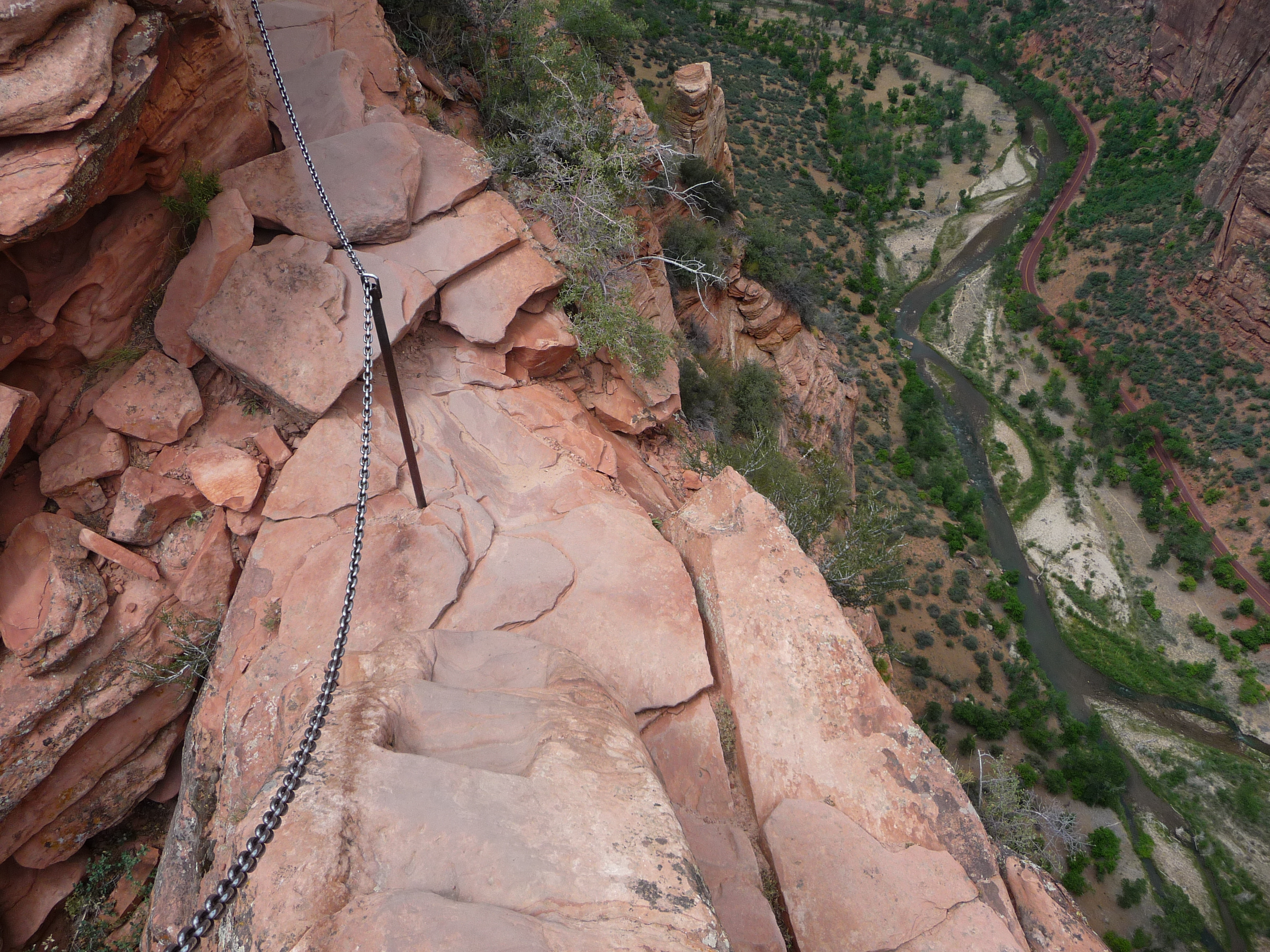 |
| By Tony Crabtree - Original work by author., CC0, https://commons.wikimedia.org/w/index.php?curid=7547844 |
 |
| The trail runs up the spine of the formation. By Mountain walrus - Own work, CC BY-SA 3.0, https://commons.wikimedia.org/w/index.php?curid=18944430 |
 |
| The view from the top. |
That was my last day of the extended back-country hiking. I ended in a campground in the main canyon floor, where I met up for dinner with my old friend Tyler, who's touring the west in search of warm and affordable climes. An excellent way to end the trek!
Day 5
I'd had ambitious plans to do a steep, 8-mile trek to the top of another viewpoint, but the canyon-floor heat and some sore feet led me to take it easy. I rode the Zion Canyon shuttle to a few low-and-easy scenic walks in the main part of the park.
 |
"The Court of the Patriarchs"
|
I ended the day at the farthest stop up the canyon, on a river walk up to the Narrows. The sun was just leaving the highest rock formations.
 |
| Temperatures cool in the shade and moisture of the canyon. |
 |
| Notice the two hikers at the bottom for scale. |
|
Day 6
This was my last morning in the park. It turned out to be a longer morning than I planned, as my flight got cancelled, and I had to book one going back 2 hours later (though after a rather leisurely breakfast out, I was cutting it close to make the original flight anyway).
I took the opportunity to get up early and drive through the Mount Carmel Tunnel on the eastern side of the park and hike to an overlook, where a few people also made it up for the sunrise.
 |
| The first rays of the sun hit the West Temple formation |
 |
| The road leading up to the tunnel, for scale. |
 |
| Proper footwear recommended. |
After a delicious breakfast back in Springdale, I hit the highway to Las Vegas, and back home!